ISMN quality flags overview
ISMN qualty contol uses different techniques to detect dubious soil moisture observations, geophysical dynamic range verification (simple threshold checks), geophysical consistency methods (ancillary data used to flag soil moisture), and spectrum-based methods (series of conditions applied to the soil moisture measurement time series and their first and second derivatives).
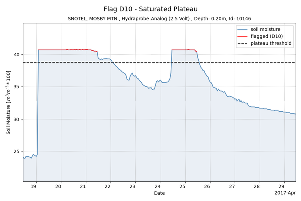
Example plot of spectrum-based ISMN quality flag D10 - "Saturated Plateau" in soil moisture time-series:
Overview flagging methods:
|
variable |
flag category |
flag |
condition |
|---|---|---|---|
|
soil moisture
|
C - reported value exceeds output format field size
|
C01 |
soil moisture < 0.0 m3/m3 |
|
C02 |
soil moisture > 0.6 m3/m3 |
||
|
C03 |
soil moisture > saturation point (derived from HWSD parameter values) |
||
|
D - questionable/dubious - geophysical based
|
D01 |
in situ soil temperature(*) < 0°C |
|
|
D02 |
in situ air temperature < 0°C |
||
|
D03 |
GLDAS soil temperature(*) < 0°C |
||
|
D04 |
soil moisture shows peaks without precipitation event (in situ) in the preceding 24 hours |
||
|
D05 |
soil moisture shows peaks without precipitation event (GLDAS) in the preceding 24 hours |
||
|
D - questionable/dubious - spectrum based
|
D06 |
a spike is detected in soil moisture spectrum |
|
|
D07 |
a negative jump is detected in soil moisture spectrum |
||
|
D08 |
a positive jump is detected in soil moisture spectrum |
||
|
D09 |
low constant values (for a minimum time of 12 hours) occur in soil moisture spectrum |
||
|
D10 |
saturated plateau (for a minimum time length of 12 hours) occurs in soil moisture spectrum |
||
|
|
(*) at corresponding depth layer |
||
|
soil temperature
|
C - reported value exceeds output format field size
|
C01 |
soil temperature < -60°C |
|
C02 |
soil temperature > 60°C |
||
|
soil surface temperature
|
C - reported value exceeds output format field size
|
C01 |
soil surface temperature < -60°C |
|
C02 |
soil surface temperature > 60°C |
||
|
air temperature
|
C - reported value exceeds output format field size
|
C01 |
air temperature < -60°C |
|
C02 |
air temperature > 60°C |
||
|
precipitation
|
C - reported value exceeds output format field size
|
C01 |
precipitation < 0 mm/h |
|
C02 |
precipitation > 100 mm/h |
||
|
soil suction
|
C - reported value exceeds output format field size
|
C01 |
soil suction < 0 kPa |
|
C02 |
soil suction > 2500 kPa |
||
|
snow water equivalent
|
C - reported value exceeds output format field size
|
C01 |
snow water equivalent < 0 mm |
|
C02 |
snow water equivalent > 10000 mm |
||
|
snow depth
|
C - reported value exceeds output format field size
|
C01 |
snow depth < 0 mm |
|
C02 |
snow depth > 10000 mm |
||
|
all dynamic variables
|
|
M |
parameter value missing |
|
|
G |
good |